
Sattva Dabaspete Location
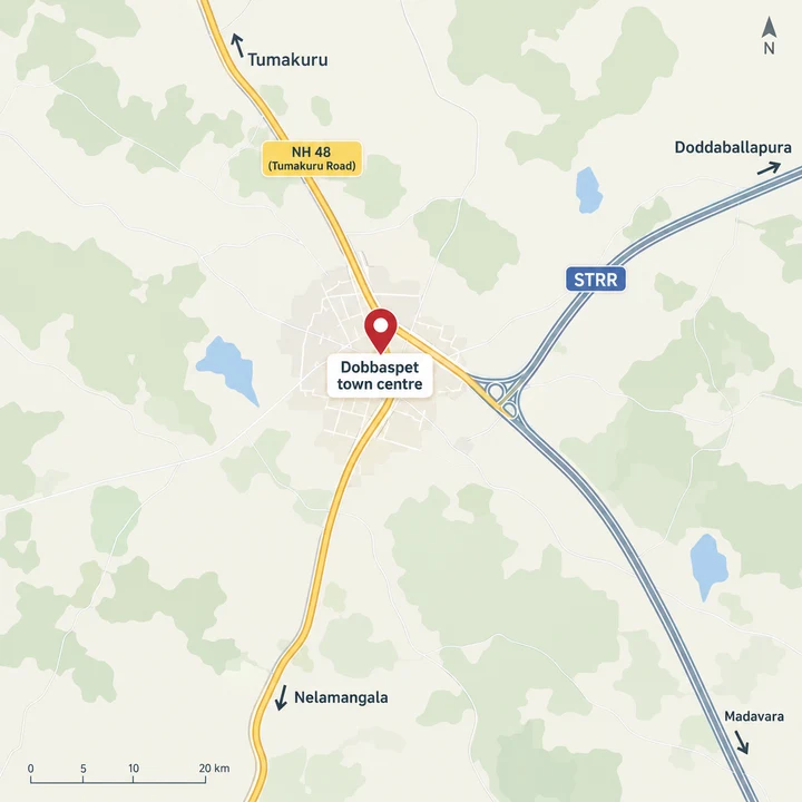
Dobbaspet is where Tumakuru Road (NH 48) meets the Satellite Town Ring Road, and that junction is the setting for the plotted development Sattva Group is understood to be planning. The town sits in Nelamangala taluk of Bangalore Rural district, its PIN is 562111, and the city of Tumakuru lies about 20.9 km up the highway by road. Locals and road signs spell the town Dobbaspet; the project name on this site, Sattva Dabaspete, follows the other common spelling.
Status: Upcoming - Sattva has not announced this layout; no K-RERA registration is shown as at 4 October 2026.
Sattva Dabaspete on Tumakuru Road
Because the ring road and the highway cross at the town, directions from anywhere on the Tumakuru Road corridor end at the same junction. Every figure on this page is measured from that point, the town centre beside the Dabaspete bus stand, rather than from a parcel that has not been announced. For location reading, Sattva Ekatra keeps the context local: commute anchors, school access, hospital reach, retail convenience, and last-mile movement decide whether the address works.
Three things shape the address. The first is the highway: NH 48 runs from Bengaluru through Nelamangala to Tumakuru and passes through the town. The second is the ring road: the Satellite Town Ring Road leaves the highway here and arcs east through Doddaballapura towards Hoskote, giving north Bengaluru a route that does not touch the city. The third is work: the KIADB Dobbaspet industrial area, home to plants such as Sami Labs and Jindal Aluminium, lies a few kilometres from the town centre, and a passenger halt on the Bengaluru-Tumakuru railway line is about 1.4 km from it by road.
Shivagange, the pilgrimage hill, is about 9 km from the town centre. For daily life, Dobbaspet itself has local schools, a primary health centre and a multispeciality hospital; established schools, tertiary hospitals and larger retail sit in Nelamangala and Tumakuru, covered in the tables below.
Roads and the Satellite Town Ring Road
The Satellite Town Ring Road stretch from Dobbaspet through Doddaballapura towards Hoskote has been open since March 2024 and tolled since June 2024. The whole Dobbaspet-Hoskote stretch, about 80 km and signed NH 648, was inaugurated on 11 March 2024. Tolling on the 42 km Dobbaspet-Doddaballapura section began on 14 June 2024 at the Hulikunte plaza, about 13.0 km by road from Dobbaspet town centre. The road has been carrying traffic for more than two years, a record a buyer can check for themselves rather than a promise.
It is a separate project with its own registration, and it is named here only as a nearby Sattva project.
The ring road's western arc, from Dobbaspet towards Magadi and Ramanagara, is a different matter. It is planned, not yet awarded, and not built, so nothing on this page assumes it. The widening of NH 48 between Nelamangala and Tumakuru has run behind schedule, with no completion date settled. Both are worth following, and neither is counted into the distances below.
Rail and Metro
Dobbaspet has its own railway halt on the Bengaluru-Tumakuru line, with Nidvanda the next station towards Bengaluru. Namma Metro is further away: the Green Line ends at Madavara, and an extension towards Tumakuru is proposed, not approved.
All distances are road distances from Dobbaspet town centre, because Sattva has not announced the parcel.
| Place | Road km | Status |
|---|---|---|
| Dobbaspet railway halt | about 1.4 | A passenger halt on the Bengaluru-Tumakuru line |
| Nidvanda railway station | about 4.8 | Next station towards Bengaluru |
| Tumakuru railway station | about 21.0 | Railway station |
| Nelamangala railway station | about 22.6 | Railway station |
| Madavara metro station | about 31.9 | Namma Metro Green Line terminus, opened 7 November 2024 |
| Nagasandra metro station | about 35.1 | Green Line station, the terminus before Madavara |
| Peenya Industry metro station | about 38.1 | Green Line station |
| Madavara to Tumakuru metro extension | not applicable | Proposed via Nelamangala and Dobbaspet; the detailed project report went to the state in May 2026 and awaits Cabinet approval; no date |
K-RIDE suburban rail does not reach this belt.
Work Hubs Around Dobbaspet
The industrial belt is the corridor's anchor. The KIADB Dobbaspet industrial area, the works around Nelamangala and Peenya Industrial Area together provide employment along the Tumakuru Road belt. Further up the highway, the Tumakuru Industrial Township at Vasanthanarasapura is under development, with a Japanese township planned inside its Phase A.
All distances are road distances from Dobbaspet town centre, because Sattva has not announced the parcel.
| Place | Road km |
|---|---|
| Sami Labs, Dobbaspet industrial area | about 1.4 |
| Jindal Aluminium, Dobbaspet | about 2.8 |
| Somapura Industrial Area (KIADB), to the estate's centre | about 3.4 |
| Varun Beverages (PepsiCo franchise) bottling plant, T Begur, Nelamangala | about 15.7 |
| Denso Kirloskar | about 20.4 |
| ABB India, Nelamangala works | about 20.6 |
| Peenya Industrial Area, to the area's centre | about 40.4 |
Schools and Hospitals
Dobbaspet has local schools, and the established CBSE and ICSE schools and colleges are in Tumakuru and Nelamangala. For health care, the town has a government primary health centre and a multispeciality hospital; tertiary care is in Nelamangala and Tumakuru.
All distances are road distances from Dobbaspet town centre, because Sattva has not announced the parcel.
| School or college | Road km |
|---|---|
| Sri Chaitanya Techno School, Kyathasandra, Tumakuru (CBSE) | about 14.2 |
| Siddaganga Institute of Technology, Tumakuru | about 18.1 |
| Tumkur University | about 18.7 |
| Nalanda Convent, Kyathasandra | about 18.8 |
| Bishop Sargant School, Tumakuru (ICSE) | about 20.4 |
| Vishal English School, Nelamangala | about 23.4 |
| Hospital | Road km |
|---|---|
| Government Primary Health Centre, Dobbaspet | about 0.4 |
| WeCare Multispeciality Hospital, Dobbaspet | about 1.0 |
| Sri Siddhartha Institute of Medical Sciences, T Begur | about 11.3 |
| M S Ramaiah Harsha Hospital, Nelamangala | about 22.6 |
| Sri Siddhartha Medical College and Hospital, Tumakuru | about 27.6 |
Retail follows the same pattern: shopping centres are in Tumakuru and Nelamangala.
Distances from Dobbaspet Town Centre
The town centre is the NH 48 junction beside the Dabaspete bus stand. From it, the roads lead to every town and city a buyer is likely to weigh up. The airport figure runs by road along the STRR and NH 44.
All distances are road distances from Dobbaspet town centre, because Sattva has not announced the parcel.
| Place | Road km |
|---|---|
| Tumakuru | about 20.9 |
| Nelamangala | about 22.6 |
| Hesaraghatta | about 35.0 |
| Doddaballapura | about 35.1 |
| Sattva Ekatra, Thippapura (nearby Sattva project) | about 36.6 |
| Yeshwantpur | about 41.2 |
| Majestic (Nadaprabhu Kempegowda Station), city centre | about 48.0 |
| Kempegowda International Airport | about 67.1 |
Honest Trade-offs
Dobbaspet rewards a particular kind of buyer, and it helps to be clear about who that is. A location at the meeting point of a national highway, a working ring road and an industrial belt suits someone planning for the long term, not someone who needs a short daily drive to the city centre.
| Consideration | What it means for a buyer |
|---|---|
| Distance from the city | About 48.0 km to Majestic and 67.1 km to the airport by road. The case for the corridor rests on its employment belt and long horizon, not on a daily commute. |
| Health care | Primary and local care are in town; tertiary hospitals are in Nelamangala and Tumakuru, 22.6 to 27.6 km away. |
| Schools | Established CBSE and ICSE schools are in Tumakuru and Nelamangala, 14.2 to 23.4 km away. |
| Metro | The Madavara extension is proposed, not approved. Nothing here depends on it. |
| Western ring road | The arc from Dobbaspet towards Magadi is planned, not yet awarded. |
| NH 48 | Widening between Nelamangala and Tumakuru has run behind schedule, and the completion date is unsettled. |
| Planning authority | Which authority sanctions the layout (the Nelamangala Planning Authority, the Satellite Town Ring Road Planning Authority or another) depends on the survey numbers, which Sattva has not announced. |
A sensible way to test the corridor is to drive it. Take Tumakuru Road from Nelamangala to Dobbaspet on a working day, join the ring road at the Dobbaspet junction and follow it towards Doddaballapura, then stop in the town and walk around the bus stand and the industrial area gates. That one trip shows the traffic, the services and the neighbours more reliably than any table, and it is the kind of first-hand check that matters even more once Sattva announces a parcel and its survey numbers.
Sattva has not announced the parcel, plot sizes or a launch date. The overview sets out what is known, the master plan explains how to read a layout plan, and the price page shows the costs to plan for. To hear when Sattva announces the layout, use the contact page. Confirm the K-RERA registration on the official K-RERA site before you pay anything.
Register Your Interest in Sattva Dabaspete
Share your name and phone number to hear when Sattva announces the layout.
Sattva Dabaspete Location FAQs
Where is Sattva Dabaspete located?
Dabaspete, also spelt Dobbaspet, is a town in Nelamangala taluk, Bangalore Rural district, with the PIN code 562111. It stands on NH 48 (Tumakuru Road), where the road meets the Satellite Town Ring Road. Because Sattva has not announced the parcel, all distances on this site are road distances from Dobbaspet town centre, and none is measured from the project.
How far is Dobbaspet from Bengaluru and the airport?
From Dobbaspet town centre, Majestic is about 48.0 km by road and Yeshwantpur about 41.2 km. Kempegowda International Airport is about 67.1 km by road, along the Satellite Town Ring Road and NH 44. The nearest Namma Metro station is Madavara on the Green Line, about 31.9 km away. These are distances from the town centre, not from the project.
How far is Dobbaspet from Nelamangala, Tumakuru and Doddaballapura?
By road from Dobbaspet town centre, Tumakuru is about 20.9 km, Nelamangala about 22.6 km and Doddaballapura about 35.1 km. The Hulikunte toll plaza on the Satellite Town Ring Road is about 13.0 km away. Nelamangala and Tumakuru are where most of the larger schools, hospitals and retail for the area are found.
Is there a metro or railway station near Dobbaspet?
Dobbaspet has a passenger railway halt on the Bengaluru-Tumakuru line, about 1.4 km by road from the town centre, and Nidvanda station is the next one towards Bengaluru at about 4.8 km. Namma Metro's Green Line ends at Madavara, which opened on 7 November 2024. An extension of about 60 km from Madavara to Tumakuru via Nelamangala and Dobbaspet is proposed: a detailed project report went to the state in May 2026 and awaits Cabinet approval. No date is set for it.
What is the status of the Satellite Town Ring Road at Dobbaspet?
The Satellite Town Ring Road stretch from Dobbaspet through Doddaballapura towards Hoskote, about 80 km and signed NH 648, was inaugurated on 11 March 2024. Tolling on the 42 km Dobbaspet-Doddaballapura section began at Hulikunte on 14 June 2024. The western arc from Dobbaspet towards Magadi and Ramanagara is planned but was still unawarded in NHAI's list as at 1 March 2026.
Are there good schools and hospitals near Dobbaspet?
Dobbaspet has local schools, a government primary health centre about 0.4 km from the town centre and WeCare Multispeciality Hospital about 1.0 km away. The established CBSE and ICSE schools are in Tumakuru and Nelamangala: Sri Chaitanya Techno School at Kyathasandra about 14.2 km, Bishop Sargant School about 20.4 km and Vishal English School in Nelamangala about 23.4 km. Tertiary care is further out, at Sri Siddhartha Institute of Medical Sciences in T Begur about 11.3 km, M S Ramaiah Harsha Hospital in Nelamangala about 22.6 km and Sri Siddhartha Medical College and Hospital in Tumakuru about 27.6 km.